
ISAIAS TURNS POST-TROPICAL AS POWER OUTAGES SURGE PAST 760,000 ACROSS U.S. SOUTHEAST
Isaias is no longer classified as a tropical hurricane after moving inland from the Florida Panhandle, but its impacts continue to intensify across the Southeast. More than 760,000 electricity customers were without power early Saturday, up by more than 300,000 from VNTV’s previous update, while heavy rain, flooding and tornado threats remained across Alabama, Georgia, Florida and South Carolina. Utility companies have mobilized thousands of additional restoration workers as damage assessments begin.
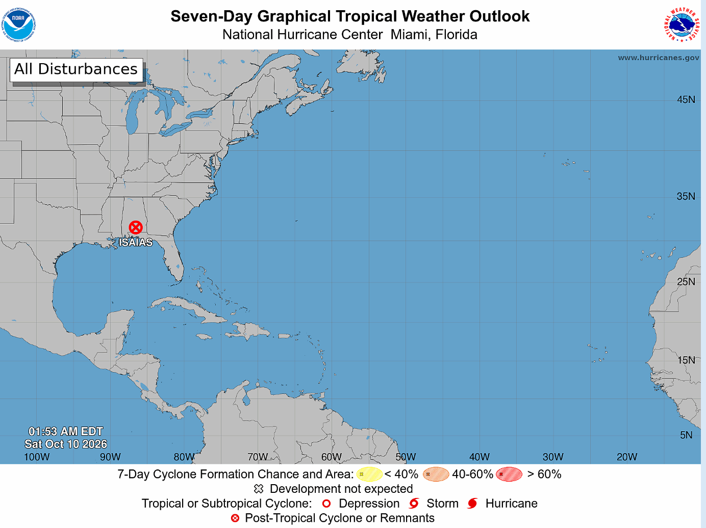
Isaias has lost its tropical characteristics after moving inland across the southeastern United States, but the storm continues to produce dangerous conditions across multiple states as power outages climbed above 760,000 customers early Saturday and heavy rain, flooding and tornado threats persisted from Alabama and Georgia into parts of Florida and South Carolina. The National Hurricane Center confirmed shortly after 2 a.m. Eastern Time that Isaias had become a post-tropical system, marking the end of its classification as a tropical hurricane, but meteorologists warned that the change in terminology should not be interpreted as the end of the emergency because the storm’s expansive circulation continues to carry destructive winds and tropical moisture deep inland.
The latest development represents a significant change from earlier overnight conditions, when Isaias was still classified as a Category 1 hurricane with sustained winds near 90 mph after striking the Florida Panhandle. FOX Weather reported at 1:51 a.m. Eastern Time that more than 760,000 electricity customers across the Southeast were without power, with the largest concentrations in the Florida Panhandle, southern Alabama and southwestern Georgia. That figure represents an increase of more than 300,000 customers from the more than 450,000 outages reported around and shortly after landfall, illustrating how the storm’s impact expanded even as its maximum sustained winds weakened. The National Hurricane Center then confirmed at 2:05 a.m. Eastern Time that the system had become post-tropical as it continued inland.
The change to post-tropical status means Isaias is no longer drawing most of its energy from the warm-core processes that define a tropical cyclone, but such a transition does not make the system harmless. Post-tropical cyclones can retain strong winds, produce intense rainfall and trigger severe thunderstorms and tornadoes over areas hundreds of miles from the storm’s center. In the case of Isaias, moisture flowing north and east from the former hurricane was continuing to produce heavy rain across Alabama and Georgia early Saturday, while forecasters maintained concern about possible tornadoes across portions of the Florida Panhandle, Georgia and South Carolina.
The electricity crisis has become one of the most immediate consequences of the storm. High winds brought down trees and utility lines across the northern Gulf Coast and inland communities overnight, while flooding and dangerous road conditions complicated access for repair crews. Alabama alone had more than 250,000 customers without electricity before the latest regional total rose above 760,000, and outages were continuing to spread into areas farther inland as the storm moved northward. The broad impact means restoration will not depend solely on reconnecting individual homes; utilities may first have to clear debris, repair transmission equipment, replace poles and restore substations before electricity can return to entire neighborhoods.
Alabama Power has mobilized approximately 5,700 additional personnel and resources from 25 states to support restoration operations, according to FOX Weather. The utility said crews were being positioned so they could begin work as soon as wind and flooding conditions made it safe to do so. That interstate deployment reflects the scale of the damage expected across the region, since major hurricane and post-hurricane outages often require thousands of line workers, tree crews, damage assessors and logistical personnel operating for days or weeks.
The growing outage number also raises concerns about hospitals, emergency communications, water systems, traffic signals and other essential infrastructure. Many major hospitals operate backup generators, but widespread grid failures can create additional pressure on fuel supplies and emergency logistics. Nursing homes, homes with medically vulnerable residents and communities dependent on electrically powered water or sewage systems can become particularly exposed when restoration takes several days. Authorities throughout the affected states have therefore urged residents to avoid downed lines and treat every fallen wire as potentially energized.
Isaias made landfall near Destin, Florida, on Friday night as a Category 2 hurricane with sustained winds of about 105 mph after spending part of the day as a stronger Category 3 storm over the Gulf. The hurricane had reached winds of around 120 mph earlier Friday before weakening somewhat as it approached the coast. Even after that weakening, its wind field was large enough to produce damaging gusts across a wide section of the Florida Panhandle and southern Alabama, while storm surge and torrential rain added to the destruction.
Communities near Destin, Fort Walton Beach, Pensacola and surrounding parts of northwest Florida reported significant flooding, fallen trees, roof damage and blocked roads during and after landfall. FOX Weather documented the roof being torn from an inn in Pensacola as hurricane-force winds moved through the city, while rainfall totals exceeded a foot in some locations. DeFuniak Springs recorded 12.46 inches of rain in one FOX Weather update, illustrating how Isaias combined wind damage with a severe freshwater flooding threat.
The extent of structural damage remains under assessment because the worst conditions occurred overnight, when emergency crews and local officials in some areas could not safely conduct comprehensive surveys. Daylight assessments are expected to provide a clearer picture of damaged homes, commercial buildings, roads, bridges, utility infrastructure and coastal facilities. The number of injuries and any confirmed fatalities could also change as search teams reach communities that were inaccessible during the height of the storm.
Isaias had already produced an unusually complicated emergency before moving ashore. Coastal communities faced evacuation orders and storm-surge warnings, while federal and state authorities activated emergency operations across Florida and Alabama. Florida deployed thousands of National Guard personnel, while President Donald Trump approved federal emergency declarations that allow the Federal Emergency Management Agency to support state and local response operations. Those preparations now shift toward damage assessment, temporary shelter, debris removal and power restoration as the storm’s main circulation moves farther inland.
The threat, however, is no longer concentrated along the coast. The National Hurricane Center and other federal forecasting agencies had warned before landfall that Isaias would carry heavy rain and strong wind well into the Southeast and Tennessee Valley, with the most dangerous weather often displaced to the east of the storm’s center. That structure is particularly important during the storm’s post-tropical phase because heavy rain bands and thunderstorms can remain intense even as the central wind speed decreases substantially.
Tornadoes remain one of the most difficult threats to manage. Tropical systems frequently generate short-lived tornadoes in their outer rain bands, particularly on the eastern and northeastern side of the circulation where low-level wind shear is strongest. FOX Weather said early Saturday that the tornado threat continued across portions of the Florida Panhandle, Georgia and South Carolina even after the National Hurricane Center changed Isaias’s classification. Earlier forecasts had already highlighted southern and central Georgia and parts of South Carolina as areas where the severe-weather risk could expand as the system moved inland.
Unlike the relatively long warning period that normally precedes a hurricane’s landfall, tornadoes embedded within tropical rain bands can develop quickly and may be difficult to see because of heavy rain. Residents far from the coast may therefore face dangerous weather despite never having experienced hurricane-force winds directly. Emergency authorities have continued advising people to keep weather alerts active overnight and avoid assuming that conditions are safe merely because Isaias is no longer classified as a hurricane.
Flooding presents a similarly persistent danger. A tropical cyclone can lose most of its wind strength but continue carrying enormous amounts of water inland, particularly when its moisture interacts with frontal systems or mountainous terrain. Forecasts before landfall called for widespread heavy rainfall across Alabama, Georgia, the Carolinas and Tennessee, and some areas could experience flash flooding before the system finally weakens and dissipates. FOX Weather had warned that the storm’s rain shield could eventually affect much of the Southeast and parts of the eastern United States.
The expanding electricity outages show why inland impacts can sometimes become more disruptive after the dramatic landfall moment has passed. When a storm first reaches the coast, attention is dominated by hurricane winds and storm surge. Hours later, however, downed trees, flooded roads, river rises and electricity failures can spread across a much larger population. Isaias is now entering that second phase, in which emergency authorities must manage simultaneous recovery operations near the Gulf Coast and ongoing severe weather farther inland.
Utility restoration is likely to become a major measure of how quickly affected communities can recover. Power crews generally cannot begin full operations until sustained winds fall below safety thresholds and flooded roads become passable. Once conditions improve, utilities conduct damage assessments before prioritizing critical facilities such as hospitals, emergency services, water treatment plants and major transmission lines. Residential customers may therefore remain without electricity even after crews become visible in their communities because the network has to be restored in a specific sequence.
The arrival of thousands of outside personnel should accelerate that process, but the number of outages means the operation could remain substantial. Alabama Power’s deployment of 5,700 additional resources from 25 states is one of the clearest indications that utilities anticipated widespread infrastructure damage rather than scattered neighborhood-level outages. Similar mutual-assistance agreements are standard in major U.S. disasters, allowing power companies outside the affected region to send trained crews, equipment and specialist vehicles before a storm arrives.
The Florida Panhandle is likely to remain one of the most difficult restoration zones because that is where Isaias made landfall and where the strongest winds initially damaged the grid. Southern Alabama has also recorded extensive outages, while southwestern Georgia is increasingly affected as the storm’s circulation shifts inland. Further increases remain possible as saturated ground makes trees easier to uproot and additional wind gusts cross areas that avoided the hurricane’s strongest coastal winds.
Emergency services also face risks from flooded roads. Vehicles can be swept away in relatively shallow moving water, and authorities routinely warn that many storm-related deaths occur after landfall when drivers attempt to cross flooded roads. Downed trees and electricity poles can create additional hazards, while damaged traffic signals can increase crash risks even in areas where the weather begins to improve.
Isaias’s landfall also disrupted offshore energy production. U.S. Gulf producers shut in a large share of oil and natural gas output ahead of the storm and evacuated personnel from offshore platforms and rigs. Reuters reported before landfall that approximately 1.5 million barrels per day of oil production and 1.3 billion cubic feet per day of natural gas had been shut in, representing roughly 72 percent of Gulf oil output and 59 percent of natural gas production at that stage. Those facilities will require inspections before full production resumes, adding an economic dimension to the storm’s aftermath.
Refineries, fuel terminals and transport infrastructure along the Gulf Coast are another area being watched closely. Even where facilities avoid direct structural damage, prolonged electricity failures or flooded access roads can interrupt operations. Fuel supply problems can also complicate recovery if utility crews, emergency vehicles and residents running generators all increase demand while distribution networks are disrupted.
The storm is particularly notable because it became the first Atlantic hurricane of the 2026 season after an unusually quiet start to the year. Isaias strengthened rapidly over the warm Gulf before reaching Category 3 intensity, demonstrating once again how quickly tropical systems can change when environmental conditions become favorable. Strong upper-level winds later weakened the system before landfall, but the reduction in category did not prevent widespread damage.
That pattern is an important reminder of the limitations of the Saffir-Simpson hurricane scale. Categories are based solely on maximum sustained wind speed and do not directly describe rainfall, storm surge, tornado potential or the size of a storm’s wind field. A weakening hurricane can therefore remain extremely dangerous, and a post-tropical system can continue producing destructive conditions long after it loses a hurricane classification.
The latest change in Isaias illustrates that principle clearly. Early Saturday, the system was no longer officially tropical, but more than three-quarters of a million electricity customers were without power, rain continued to fall heavily over Alabama and Georgia, tornadoes remained possible farther east, and emergency authorities were still assessing damage in the landfall zone. The meteorological transition is important for forecasting, but it does not mark the end of the disaster.
Federal and state emergency agencies will now increasingly focus on recovery while continuing to monitor the storm’s inland path. Florida and Alabama have already received federal emergency support, while local governments are beginning road clearing, infrastructure assessments and shelter operations. Georgia and the Carolinas may face increasing impacts as the remnants move northeastward, particularly if heavy rain bands repeatedly cross the same areas.
Residents returning to damaged neighborhoods are being advised to avoid flooded roads, unstable structures, downed power lines and improperly operated generators. Carbon monoxide poisoning from portable generators is a recurring cause of deaths after major hurricanes, especially when generators are used inside homes, garages or other enclosed areas. Electrical fires and injuries during debris removal are additional post-storm hazards that often emerge after winds begin to ease.
The economic impact will take longer to measure. Damage to homes, businesses, power systems, vehicles, agricultural land and public infrastructure could produce substantial insured and uninsured losses, while prolonged electricity outages can shut businesses and disrupt schools and government services. Agriculture in parts of Alabama, Florida and Georgia may also suffer from excessive rain and wind, particularly where crops were close to harvest.
The storm’s effect on vulnerable residents is another major concern. People living in manufactured homes, low-income communities or properties without adequate insurance can face much longer recovery periods than those with stronger financial resources. Extended power failures also disproportionately affect older people and residents with medical conditions requiring refrigerated medication or electrically powered equipment.
Emergency authorities will therefore be watching restoration times as closely as damage totals. If most customers regain electricity quickly, the disruption may remain manageable despite the large headline number. If extensive transmission or distribution infrastructure has been destroyed, some communities could face much longer outages and require additional state or federal assistance.
The number of customers without power is also not the same as the number of individual people affected. A single utility customer account may represent an entire household or business, meaning the 760,000 figure could translate into well over one million people experiencing loss of electricity. The exact population affected will depend on household size and the mix of residential and commercial accounts.
The next National Hurricane Center and National Weather Service updates will provide a clearer picture of how quickly the post-tropical system is weakening and where the most dangerous rainfall and tornado threats are shifting. Forecasts indicate that the circulation will continue north and northeast through the interior Southeast before eventually dissipating, but rain associated with the system may continue beyond the point at which the former hurricane’s center becomes poorly defined.
For VNTV’s earlier coverage, the important change is substantial. Isaias was previously reported as a Category 1 hurricane with sustained winds of 90 mph after weakening inland. It is now officially post-tropical, while the electricity crisis has worsened from more than 450,000 outages to more than 760,000 affected customers. Those developments mark a new phase of the disaster rather than a repetition of Friday night’s landfall.
The coastal hurricane emergency is becoming an inland flooding, electricity and severe-weather emergency. The winds that originally made Isaias a hurricane are weakening, but their consequences are still unfolding across the power grid, transportation network and communities in its path. Tens of thousands of utility personnel and emergency responders will spend Saturday assessing damage and beginning restoration work while residents in Alabama, Georgia, Florida and South Carolina remain alert for flooding and tornadoes.
The full cost of Isaias will not be known until daylight surveys, utility inspections and local emergency reports are completed. Structural damage, casualties and infrastructure losses remain under assessment, and the outage figure may continue fluctuating as some customers are restored and others lose service farther inland. What is already clear is that the end of Isaias’s hurricane classification has not ended its destructive impact: the storm has entered its post-tropical phase with more than 760,000 electricity customers offline and millions of people still facing rain, flooding, dangerous wind gusts and the possibility of tornadoes across the southeastern United States.