
HURRICANE ISAIAS STRENGTHENS TO CATEGORY 2 AS GEORGIA DECLARES STATEWIDE EMERGENCY
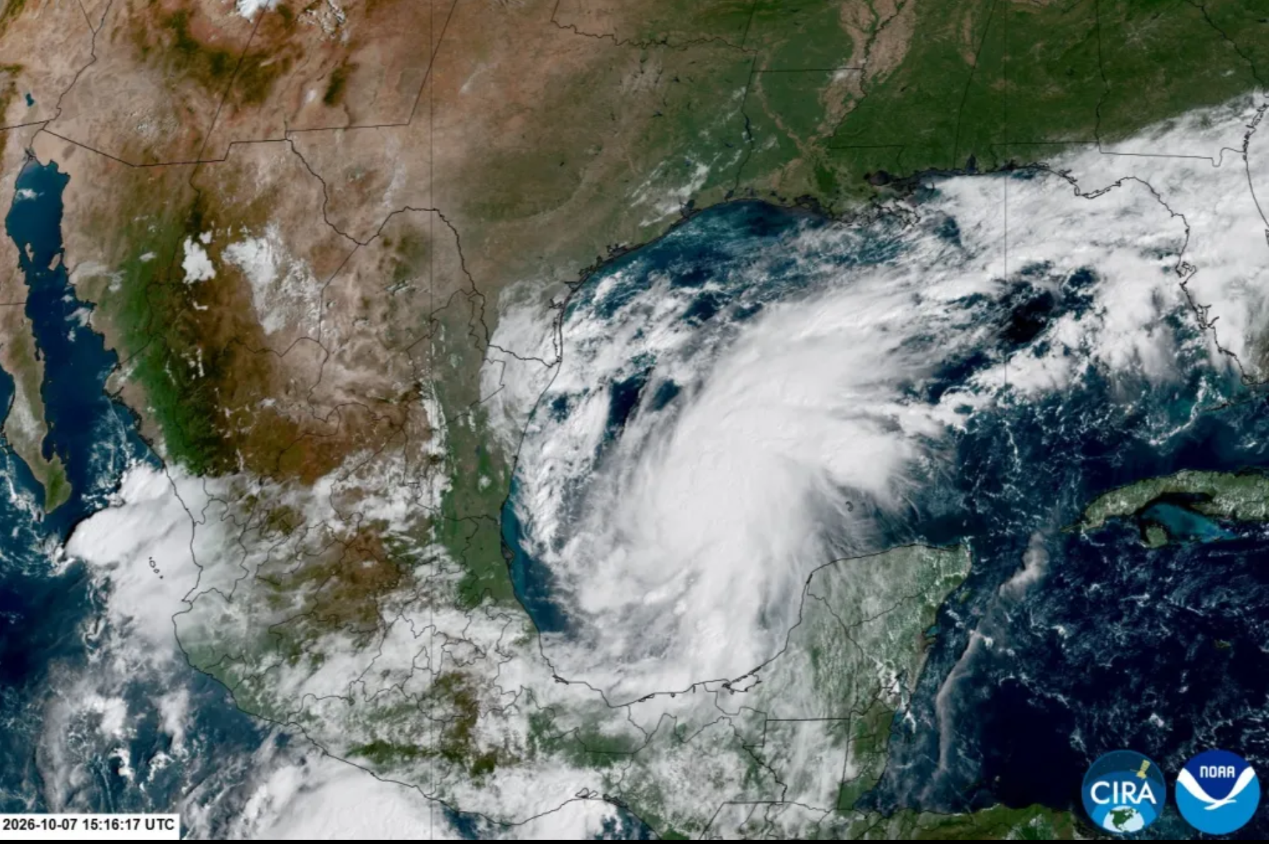
Hurricane Isaias has strengthened to Category 2 with maximum sustained winds of 105 mph as it approaches the northern Gulf Coast. Georgia Governor Brian Kemp has declared a state of emergency across all 159 counties ahead of expected heavy rain, flooding, damaging winds and possible tornadoes. Florida and Alabama are also preparing for major impacts, while Gulf energy companies have shut down roughly 63% of offshore oil production.
Hurricane Isaias has strengthened into a powerful Category 2 storm over the Gulf of Mexico as it moves toward the northern U.S. Gulf Coast, prompting Georgia Governor Brian Kemp to declare a state of emergency across all 159 counties while emergency officials prepare for heavy rain, damaging winds, flooding and possible tornadoes extending well inland from the eventual landfall zone. The National Hurricane Center said Isaias had maximum sustained winds of 105 mph early Friday and was moving north-northeast at about 14 mph, with the storm expected to approach the northern Gulf Coast later Friday before making landfall late Friday or early Saturday.
As of the National Hurricane Center’s 1 a.m. Central Daylight Time advisory on Friday, October 9, Isaias was located roughly 230 miles south of the mouth of the Mississippi River, with a minimum central pressure of 972 millibars. Hurricane hunters from both NOAA and the U.S. Air Force were flying through the storm as forecasters monitored its strength and structure. Storm-surge and hurricane warnings remained in effect along a broad stretch of the northern Gulf Coast, where residents were being urged to complete preparations for potentially dangerous coastal flooding, destructive winds and intense rainfall.
The storm had strengthened quickly after becoming the first hurricane of the unusually quiet 2026 Atlantic season. By Thursday evening, sustained winds had increased to 100 mph, and the system continued intensifying overnight to 105 mph, placing it firmly within Category 2 on the Saffir-Simpson Hurricane Wind Scale. Category 2 hurricanes have sustained winds between 96 and 110 mph and are capable of causing extensive damage, particularly to roofs, trees, power lines and poorly secured structures.
Forecasters have warned that further strengthening remains possible before landfall, although increasing wind shear near the coast could prevent Isaias from reaching or maintaining major-hurricane intensity. Earlier forecasts suggested the storm could briefly approach Category 3 strength, which begins at 111 mph, before environmental conditions become less favorable close to the coast.
The projected landfall zone currently stretches across portions of the northern Gulf Coast, including parts of coastal Alabama and the Florida Panhandle. The precise point of landfall remains subject to change because even small shifts in the storm’s track can substantially alter which communities experience the strongest winds and highest storm surge.
Georgia is not currently expected to take the direct coastal landfall, but the state could experience significant effects as the hurricane moves inland and northeastward. Kemp’s statewide emergency declaration allows Georgia agencies to position personnel, emergency equipment and supplies ahead of the storm and gives state officials greater flexibility to respond rapidly if flooding, wind damage or power outages become widespread.
Kemp said Georgia was preparing for the worst while hoping the storm’s effects would be less severe than feared. He urged residents to stock food, drinking water, batteries, flashlights and other emergency supplies before conditions begin deteriorating, particularly because power outages and travel disruptions could continue after the strongest weather has passed.
The governor also directed the Georgia Emergency Management and Homeland Security Agency to activate the State Operations Center beginning Friday afternoon. That activation allows state agencies, utility companies, local emergency managers and other responders to coordinate resources from a central location as Isaias approaches.
The state of emergency applies to every county in Georgia rather than only communities closest to the Florida and Alabama borders. That statewide approach reflects the unusually broad range of hazards associated with the storm once it begins moving inland. Tropical systems can weaken after landfall while still producing dangerous flooding, tornadoes and damaging wind gusts hundreds of miles from the coast.
The National Weather Service in Peachtree City said north and central Georgia could experience impacts from Friday evening through early Sunday. Forecasters are warning of a prolonged period of strong winds, heavy rain capable of causing localized flash and river flooding, and the possibility of several tornadoes embedded within the storm’s outer rain bands.
Some areas could experience wind gusts of 30 to 40 mph or higher for an extended period, with stronger gusts possible depending on the eventual track. Saturated ground combined with persistent winds could bring down trees even in locations that never experience hurricane-force conditions, increasing the risk of blocked roads and power outages.
Tropical storm watches and warnings have been issued for portions of Georgia, while high-wind watches cover some northern and central areas. Southwest Georgia is among the first parts of the state expected to feel stronger winds and rain as Isaias moves inland, but severe-weather risks could extend toward central and northern sections later in the weekend.
The hurricane is also expected to bring a tornado threat east and northeast of its center. Tropical cyclones frequently generate short-lived tornadoes in their outer rain bands, particularly on the right side of the storm’s path. Those tornadoes can develop quickly and may provide little warning, making nighttime impacts especially dangerous.
Heavy rainfall may prove to be one of the most widespread hazards in Georgia. Even if Isaias weakens rapidly after landfall, its moisture could produce several inches of rain across large parts of the state. Areas that receive repeated bands of heavy rain could experience flash flooding, while rivers may rise more slowly after the storm moves away.
The greatest life-threatening hazard closer to the Gulf Coast remains storm surge. The National Hurricane Center has warned that water could rise several feet above normally dry ground in portions of the warning area as strong onshore winds push Gulf water toward the coast. In some locations, surge forecasts have reached approximately five to seven feet, depending on the storm’s exact track and timing relative to high tide.
Mandatory and voluntary evacuations have been ordered in vulnerable coastal communities in Florida and Alabama, where emergency shelters are being opened and residents are securing homes and businesses. Authorities have repeatedly warned that people in surge zones should not focus solely on the hurricane’s category, because coastal flooding can become deadly even when a storm weakens before landfall.
Florida and Alabama have also activated emergency procedures, while thousands of National Guard personnel and local responders have been placed on standby across affected states. Officials are preparing for possible rescues, debris removal and extended electricity disruptions once Isaias crosses the coastline.
The storm has already disrupted one of the most strategically important energy-producing regions in the United States. Offshore oil and gas operators across the Gulf of Mexico have evacuated workers, halted production and shut down platforms as Isaias moves through the region.
Roughly 63 percent of Gulf oil production and approximately 57 percent of natural gas output had been taken offline by Thursday as companies including Shell, Chevron, BP and others reduced operations ahead of the storm. That represents around 1.3 million barrels of daily oil production temporarily removed from the market.
The disruptions are significant because the Gulf of Mexico remains one of the largest oil-producing areas in the United States and is surrounded by major refineries, pipelines and fuel-distribution infrastructure. A prolonged shutdown or damage to offshore installations could tighten already sensitive energy markets, although facilities typically begin restarting once inspections confirm conditions are safe.
Oil markets were already experiencing substantial volatility because of geopolitical tensions and constrained refined-product supplies, making the hurricane an additional source of uncertainty. Traders are watching both offshore production losses and the possibility of disruptions to refineries and pipelines near the northern Gulf Coast.
The hurricane’s arrival is particularly unusual because the Atlantic season had remained remarkably quiet through the summer and early fall. Isaias became the first Atlantic hurricane of 2026 only in early October, making it one of the latest first hurricanes of a season in more than a century of records.
A strong El Niño has contributed to the suppressed Atlantic hurricane season by increasing upper-level winds that make it more difficult for tropical systems to organize. However, unusually warm Gulf waters provided enough energy for Isaias to develop and strengthen rapidly once atmospheric conditions became more favorable.
That combination has produced what meteorologists describe as a contest between warm ocean temperatures encouraging intensification and stronger upper-level winds attempting to disrupt the storm. Isaias has so far managed to organize despite moderate wind shear, developing an eye and strengthening steadily as it moved through the Gulf.
The hurricane’s name may be familiar because another Hurricane Isaias affected the Caribbean and eastern United States in 2020. The name was not retired after that storm and therefore returned under the World Meteorological Organization’s rotating Atlantic naming system for the 2026 season.
The 2020 Isaias caused widespread power outages, flooding and tornadoes along the U.S. East Coast after making landfall in North Carolina. The current storm is a separate hurricane following a very different track through the Gulf of Mexico.
For Georgia, the most important factor over the next day will be Isaias’s track after landfall. A path farther west could reduce some of the state’s strongest wind impacts while potentially shifting heavier rain elsewhere, while a track farther east could bring more of Georgia into the storm’s strongest eastern side.
Emergency planners are therefore preparing across a much larger area than the forecast center line alone. Hurricane forecasts always include uncertainty, and significant impacts can occur well outside the cone showing the probable path of the storm’s center.
Kemp’s emergency order is intended to allow state agencies to act before conditions deteriorate rather than waiting for individual counties to experience damage. It enables officials to mobilize resources, coordinate emergency transportation and position equipment where it may be needed most.
Georgia Power and other utilities are also preparing restoration crews for possible outages. Strong winds combined with saturated soil can uproot trees and bring branches onto power lines, and restoration may take longer if crews have difficulty reaching damaged areas while flooding or high winds continue.
Emergency officials are urging residents to charge mobile devices, identify safe interior rooms for tornado warnings and avoid flooded roads. Drivers are repeatedly reminded that even shallow-looking floodwater can conceal damaged pavement or become strong enough to move vehicles.
Schools, local governments and businesses across the Southeast are reviewing schedules as the storm approaches. Some events have already been postponed or moved because of the forecast, while universities and sports organizers continue monitoring conditions for the weekend.
The storm could also affect travel well outside the immediate landfall zone. Heavy rain and strong winds may disrupt flights across airports in Florida, Alabama and Georgia, while fallen trees and flooding could make interstate and local road travel dangerous.
Meteorologists caution that the storm’s Category 2 designation describes only its maximum sustained wind speed and does not measure rainfall, tornado or storm-surge risk. A weakening hurricane can still produce catastrophic flooding after landfall, particularly if it moves slowly or interacts with other weather systems.
Isaias is currently moving at a relatively steady pace, which may limit the amount of time any one coastal area remains under the hurricane’s most intense rain. Even so, the storm’s broad moisture field means significant rainfall could extend across several states as the remnants move through the Southeast.
Officials in Georgia are also paying close attention to rivers and low-lying communities that have historically flooded during tropical systems. River flooding can peak after the strongest winds have ended as rainfall from upstream areas moves through drainage systems.
Residents who live near creeks, rivers and flood-prone roads have been encouraged to monitor local warnings and be prepared to move to higher ground. Emergency managers say people should not assume they are safe merely because they live far from the coast.
The hurricane’s strengthening also underscores how quickly tropical forecasts can change. Isaias moved from tropical-storm status to Category 2 hurricane strength in a relatively short period, reinforcing the need for residents to follow updated advisories rather than relying on forecasts issued a day earlier.
NOAA and Air Force reconnaissance flights will continue sampling the storm as it approaches landfall. Those aircraft provide forecasters with direct measurements of wind, pressure and storm structure, allowing the National Hurricane Center to adjust intensity estimates and warnings in near real time.
As of the latest verified advisory available early Friday, Isaias remained a Category 2 hurricane with sustained winds of 105 mph and was moving north-northeast at 14 mph. Storm-surge and hurricane warnings remained in effect across the northern Gulf Coast, and Georgia’s statewide emergency declaration remained active.
The next several hours will determine whether Isaias strengthens further before landfall or begins weakening under increasing wind shear. Even if weakening begins, officials stress that preparations should already be complete because conditions along the northern Gulf Coast are expected to deteriorate during Friday.
Georgia’s most significant impacts are expected after landfall, as the storm tracks inland from Friday night into the weekend. Heavy rainfall, localized flooding, tornadoes and prolonged gusty winds are the primary threats currently identified by the National Weather Service.
For coastal Gulf communities, the situation is more immediate, with storm surge and hurricane-force winds posing the greatest danger. Evacuations and final preparations are underway as authorities urge residents to follow local instructions rather than waiting for additional changes in the storm’s category.
The broader economic effects will also be watched closely. Temporary shutdowns across Gulf energy production, transportation interruptions and potential infrastructure damage could have consequences beyond the states directly affected by Isaias, particularly if oil and natural gas facilities remain offline after the storm.
For now, the most important message from emergency authorities is straightforward: Isaias has become a dangerous Category 2 hurricane, its exact landfall point remains uncertain, and the threat extends far beyond the coastline. Georgia’s statewide emergency declaration reflects the expectation that the storm could affect large portions of the state even without a direct hurricane landfall there.
Residents across the northern Gulf Coast and Southeast are being advised to continue following official forecasts through the weekend. The storm’s track and intensity may still change, but preparations for damaging winds, flooding, tornadoes and power outages are already underway from the coast deep into the interior.