

HURRICANE TRUDY LASHES MEXICO’S PACIFIC COAST AS CATEGORY 2 STORM TRIGGERS FLOOD AND LANDSLIDE WARNINGS
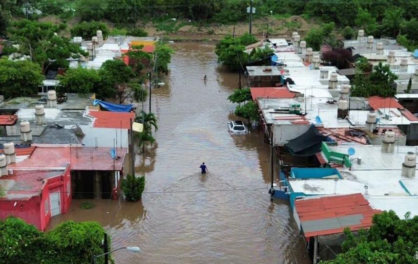
Hurricane Trudy is bringing heavy rain and strong winds to Mexico’s Pacific coastline as a Category 2 storm with maximum sustained winds of around 100 mph. The National Hurricane Center says the hurricane is moving northwest at about 9 mph and remains close to the coasts of Colima and Jalisco. A hurricane warning is in effect from Manzanillo to Cabo Corrientes, while authorities are warning of dangerous flooding, landslides and high waves. Parts of Michoacán, Colima and Jalisco could receive 4 to 8 inches of rain, with isolated totals near 12 inches.
Hurricane Trudy is bringing heavy rain, strong winds and dangerous coastal conditions to parts of Mexico’s southwestern and west-central Pacific coastline as authorities warn that the Category 2 storm could trigger life-threatening flooding and landslides in already saturated areas. The United States National Hurricane Center said early Sunday that Trudy had maximum sustained winds of approximately 100 mph, or 155 kilometres per hour, and was moving northwest at about 9 mph. At the latest advisory, the centre of the storm was positioned roughly 135 miles south of Cabo Corrientes in Jalisco and about 115 miles west-southwest of Manzanillo in Colima, placing some of Mexico’s most exposed Pacific coastal communities directly within the storm’s rain and wind field.
A hurricane warning remains in effect along the Mexican coast from Manzanillo northward to Cabo Corrientes, while a tropical storm warning remains in place for Las Islas Marías. The National Hurricane Center said Trudy’s centre was expected to remain close to the Mexican coastline through Sunday evening before moving farther offshore to the south of the Baja California Peninsula. Even if the eye does not make a direct landfall in a heavily populated area, forecasters say the storm’s outer bands are already capable of producing damaging rainfall, strong gusts and dangerous surf over a broad stretch of coastline.
The most immediate concern is rainfall rather than wind alone. The National Hurricane Center expects Trudy to bring between 4 and 8 inches of rain to parts of Michoacán, Colima and Jalisco, with isolated totals of around 12 inches near the coast. That amount of rain can overwhelm drainage systems, rapidly raise rivers and streams and destabilise hillsides, particularly in mountainous areas where water can move downhill with enormous force. Authorities have warned that communities near steep terrain face a heightened risk of mudslides, while low-lying neighbourhoods and river basins could experience flash flooding even if the storm’s centre remains offshore.
The latest update marks an important change from earlier VNTV coverage, when the primary focus was on Trudy’s approach and whether the hurricane would intensify further before reaching Mexico. The danger is no longer only a forecast possibility. Heavy rain and strong winds are now affecting sections of the coast, and emergency authorities are moving from preparation into active response. Residents in vulnerable communities have been advised to closely follow evacuation instructions, avoid flooded roads and stay away from rivers, streams and unstable slopes as the storm continues moving parallel to the coastline.
The Mexican Navy has urged both mariners and coastal residents to exercise extreme caution because Trudy is generating high waves, intense rainfall and conditions capable of producing rising rivers, flooding and landslides. The warning is particularly important for fishing communities and people working near ports because dangerous surf can develop well away from the hurricane’s centre. Strong swells can damage boats, affect harbour operations and create life-threatening rip currents along beaches that may otherwise appear far removed from the storm’s strongest winds.
Authorities in Colima have said the overall risk level remains manageable for now, but they have also warned that the ground is already saturated following successive Pacific storms. Saturated soil dramatically increases the danger posed by new rainfall because the ground has less capacity to absorb additional water. Once that capacity is exceeded, rain runs rapidly across the surface, flooding streets and channels while also weakening slopes that may collapse with little warning.
That concern is especially important in western Mexico, where the landscape includes mountains close to the coastline. Tropical systems can force moist air upward against those mountains, intensifying rainfall over relatively small areas. Communities that receive far more rain than neighbouring districts can therefore face serious flooding even when regional rainfall totals appear moderate.
Manzanillo is one of the areas being watched most closely because of its position near Trudy’s path and its importance as a major Pacific port. The city has experienced damaging flooding during previous storms, and low-lying neighbourhoods can become vulnerable when intense rainfall overwhelms drainage systems. Port authorities and emergency services are monitoring conditions closely because disruption in Manzanillo can affect not only local residents but also national trade flows through one of Mexico’s most important commercial gateways.
Cabo Corrientes and the surrounding coast of Jalisco are also exposed to the hurricane’s movement. The area lies south of Puerto Vallarta and includes mountainous terrain that can amplify the danger from intense rainfall. Even if the strongest winds remain offshore, repeated rain bands moving across the same locations could create the conditions for flash floods and landslides.
The National Hurricane Center’s early Sunday advisory placed Trudy at 18.5 degrees north and 106.1 degrees west, with a minimum central pressure of 976 millibars. Those measurements confirm that the hurricane remains a powerful tropical cyclone even though it is below major hurricane strength. A Category 2 storm is still capable of producing destructive winds, dangerous storm conditions and severe rainfall impacts, particularly where buildings, roads and drainage infrastructure are already vulnerable.
Trudy’s recent intensity has fluctuated significantly. Earlier forecasts suggested the system could become a major hurricane, and at one stage preliminary estimates briefly classified it at a higher category before satellite wind information indicated that it was weaker than initially thought. By Saturday and early Sunday, the storm had settled at Category 2 strength with sustained winds around 100 mph. That change illustrates why hurricane forecasts are updated frequently, because intensity can rise or fall quickly in response to atmospheric conditions, ocean temperatures and internal changes within the storm.
For people living along the coast, those technical changes do not reduce the need for caution. A storm does not need to reach Category 3 or higher to produce deadly flooding. In many tropical cyclones, water causes more deaths than wind, particularly when residents underestimate rapidly rising rivers or attempt to drive through flooded roads.
Mexican emergency authorities have repeatedly warned residents not to cross flooded streets, bridges or river channels. Water that appears shallow can hide damaged roads or become strong enough to sweep away vehicles. Mountain communities face a different danger because landslides can block roads, isolate villages and damage homes with little warning once the soil becomes saturated.
Residents have also been advised to secure outdoor objects, charge mobile phones, prepare emergency supplies and identify safe shelter locations. Families in flood-prone areas should be prepared to leave quickly if local authorities order an evacuation. Emergency kits typically include drinking water, food, medication, identification documents, torches and battery-powered communication equipment.
The storm arrives during an unusually active period in the eastern Pacific. Mexico has already dealt with several significant tropical systems this season, leaving some regions with saturated ground and damaged infrastructure before Trudy’s arrival. Recent storms have caused flooding, deaths and transport disruption along parts of the Pacific coast, making communities more vulnerable to additional rainfall.
That cumulative effect is important. A road that survived one storm may have weakened foundations when the next storm arrives. Hillsides that absorbed weeks of rainfall can become unstable. Rivers that are already elevated require less additional rain to overflow. Emergency resources can also become stretched when authorities are responding to repeated disasters within a short period.
Scientists have linked the exceptionally active Pacific hurricane season partly to strong El Niño conditions and unusually warm ocean temperatures. Warm water provides energy that allows tropical cyclones to develop and intensify, while favourable atmospheric conditions can help storms remain organised for longer periods. Recent research has also highlighted the contribution of human-driven climate warming to some unusually intense Pacific storms, although scientists analyse the influence of climate change on each event separately rather than attributing every hurricane directly to global warming.
Trudy itself developed rapidly over the Pacific before turning toward Mexico. The storm strengthened while moving northward and northwestward, drawing energy from warm ocean water and producing a large area of thunderstorms around its centre. Satellite imagery has shown the hurricane’s cloud structure expanding as it approached the coast, allowing rain bands to reach land even while the centre remained over water.
That distinction between the centre and the wider circulation is important because residents sometimes assume they are safe if the forecast track keeps the hurricane offshore. Tropical cyclones can extend hundreds of kilometres beyond the eye, and some of the heaviest rainfall may occur far from the exact centre line. Coastal mountains can further enhance rainfall when moist air is forced upward over the terrain.
The hurricane warning from Manzanillo to Cabo Corrientes means hurricane conditions are expected somewhere within that stretch of coastline. People inside the warning area should therefore act as though damaging conditions are possible even if the forecast track appears to keep the storm slightly offshore.
Las Islas Marías remains under a tropical storm warning, reflecting the possibility of strong winds as Trudy moves northwest. The islands sit offshore from Nayarit and can be affected as the hurricane begins moving away from the mainland coastline. Mariners throughout the area face particularly hazardous conditions because waves and wind can remain dangerous even outside the formal warning zones.
The National Hurricane Center said a previous tropical storm warning farther southeast, east of Punta San Telmo toward Lázaro Cárdenas, had been discontinued as Trudy moved farther northwest. That change shows that the threat is gradually shifting along the coast rather than disappearing. Communities farther south may experience improving wind conditions while Jalisco, Colima and surrounding areas remain exposed to heavy rainfall and dangerous seas.
Emergency authorities are also concerned about power cuts. Strong winds can bring down trees and power lines, while flooding can damage electricity infrastructure and make repairs difficult. Residents have been advised to avoid fallen cables and report damaged electrical infrastructure rather than attempting to move it.
Mobile and internet services can also become unreliable during severe storms, particularly if power is lost at communication towers. Families are encouraged to agree in advance on how they will contact each other and where they will meet if they become separated.
Coastal tourism could also be affected. Jalisco and Colima contain popular beaches, resorts and fishing communities, and heavy surf can make recreational activity extremely dangerous. Authorities may close beaches or restrict marine operations even in locations that do not experience destructive winds.
Travellers should expect possible road disruptions, especially along routes that pass through mountainous terrain. Heavy rain can trigger rockfalls and mudslides, while flooded bridges or damaged roads can isolate communities. Airlines and bus operators may also adjust services if conditions worsen around airports and major transport corridors.
The agricultural sector faces its own risks. Heavy rain and wind can damage crops, flood farmland and disrupt livestock operations. Farmers in low-lying areas may experience waterlogging, while hillside agricultural land can be vulnerable to erosion.
Fishermen are among the groups facing the most immediate danger. Small boats are especially vulnerable to high waves and rapidly changing weather, and Mexico’s Navy has urged the maritime community not to underestimate conditions. Even experienced fishermen can be overwhelmed when tropical cyclone winds combine with powerful swells.
The storm also creates risks for ports and shipping. Manzanillo handles a large share of Mexico’s Pacific container traffic, and authorities may restrict or suspend operations when winds and waves exceed safe limits. Temporary port closures can delay cargo movements but are often necessary to protect workers, vessels and infrastructure.
The exact economic impact will depend on how close Trudy remains to land and how long its rain bands continue affecting the coast. A storm that remains offshore may cause limited structural wind damage while still producing extensive flooding. Conversely, a slight shift toward land could expose more communities to hurricane-force winds.
Forecast uncertainty therefore remains important. Hurricane tracks have improved significantly over recent decades, but small changes in direction can matter greatly when a storm is moving close to a coastline. Residents should rely on official updates rather than assuming that earlier forecasts will remain unchanged.
The National Hurricane Center issues advisories several times each day during active storms, with intermediate updates when conditions require them. The 12 a.m. Central Standard Time advisory on October 18 confirmed that Trudy remained a Category 2 hurricane with 100 mph winds and was moving northwest at 9 mph. Anyone in the affected region should continue checking the latest official information because those figures can change as new satellite, aircraft or surface observations become available.
The current rainfall forecast of 4 to 8 inches with isolated totals near 12 inches represents a major reduction from some earlier forecasts that suggested isolated totals could reach around 15 inches. That does not mean the danger has disappeared. Twelve inches of rain over steep or already saturated terrain can still produce severe flash flooding and destructive landslides.
Rainfall forecasts also describe broad regional expectations rather than what every town will receive. Individual thunderstorms within the hurricane’s rain bands can produce much higher local rates over short periods. A community receiving several inches in only a few hours can flood rapidly even if its final storm total remains below the regional maximum.
Storm surge and high waves remain additional hazards along exposed coastal areas. While the latest public reporting has focused primarily on rainfall and wind, powerful waves can erode beaches, damage waterfront structures and push water into low-lying coastal zones. Residents should not approach beaches to watch the storm because large waves can suddenly sweep people into the sea.
The Mexican Navy’s caution to coastal residents reflects this wider range of dangers. Hurricanes do not produce a single threat but a combination of wind, water, waves and secondary hazards such as landslides and power failures. Emergency planning must account for all of them simultaneously.
Authorities are likely to keep shelters and emergency response teams prepared throughout Sunday as the storm moves along the coast. If rainfall intensifies, evacuations could become necessary in the most vulnerable areas. Local instructions should take priority because municipal authorities have the best information about neighbourhood-level risks.
The public should also be cautious about misinformation circulating online. Dramatic videos from previous hurricanes are frequently reposted during new storms and presented as current footage. Images should be verified before being shared, particularly when they claim to show destroyed infrastructure, deaths or emergency conditions in specific communities.
As of the latest confirmed update, there were no widely reported mass casualty figures directly attributed to Trudy’s current passage along the coast. The primary focus remains prevention, particularly avoiding deaths from flooding, landslides and dangerous sea conditions.
That could change quickly if heavy rainfall continues for several hours. Flood disasters often develop after the strongest winds have passed because rivers take time to rise and hillsides can fail after prolonged saturation. Residents should therefore continue following warnings even if local winds temporarily weaken.
Mexico has extensive experience responding to Pacific hurricanes, but repeated storms can expose weaknesses in infrastructure and emergency capacity. Rural communities may have limited road access, while poorer households often live in buildings less able to withstand flooding or high winds.
Climate and development patterns also influence risk. Rapid urbanisation can increase runoff when natural ground is replaced by concrete, while construction on hillsides and floodplains can put more people directly in harm’s way. Drainage systems may also struggle to cope with extremely intense rainfall.
This means the damage caused by a hurricane depends not only on the storm’s strength but also on where people live, the quality of infrastructure and how quickly warnings reach vulnerable communities. Two areas experiencing similar rainfall can suffer very different consequences depending on those factors.
For Mexico’s Pacific states, the immediate priority is getting through Sunday safely. Trudy is expected to remain close enough to the coastline to continue producing heavy rain and strong winds before eventually moving away toward waters south of the Baja California Peninsula.
The storm’s future intensity will matter, but the current danger already exists. Residents do not need Trudy to become stronger for flooding or landslides to occur. The moisture now moving onshore is sufficient to create potentially life-threatening conditions in areas where the terrain and soil are already vulnerable.
Emergency officials will therefore be watching rainfall totals as closely as wind speeds. If rivers begin rising rapidly or landslides block important roads, rescue operations may become more difficult. Authorities are urging people to move before routes become impassable rather than waiting until water reaches homes.
For people farther inland, the storm should not be dismissed as only a coastal problem. Tropical moisture can travel well inland, and mountainous terrain can produce intense rain many kilometres from the sea. Flash flooding can therefore develop in communities that never experience hurricane-force winds.
The latest AP and National Hurricane Center reports confirm that Trudy has moved from a developing offshore threat into an active weather emergency affecting Mexico’s Pacific coast. The hurricane remains powerful, its rain bands are reaching populated areas and the risk of dangerous flooding and landslides is expected to continue through Sunday.
Residents between Manzanillo and Cabo Corrientes remain under a hurricane warning, while people across Michoacán, Colima and Jalisco should remain alert for rapidly changing conditions. With up to around 12 inches of rain possible in isolated areas and the ground already saturated from previous storms, the most serious danger may come not from the hurricane’s eye but from the water it leaves behind.
The storm will eventually move away, but the next several hours remain critical. Mexico’s emergency authorities are asking residents to avoid unnecessary travel, stay away from rivers and unstable slopes, follow evacuation orders immediately and continue monitoring official forecasts until Trudy is safely beyond the coastline.